 Contact Us
AI TECHNOLOGY TO MEASURE RIVER LEVELS WITH HIGH ACCURACY
(Location: Minato-ku, Tokyo, CEO: Ryota Kanai, hereinafter referred to as " Araya"), a company engaged in the development of artificial intelligence (AI) technology and solutions, has participated in and provided technical support for a demonstration experiment in the field of disaster prevention (hereinafter referred to as the "Experiment") conducted in Tochigi City from January 2021. (Location: Minato Ward, Tokyo, Japan; ), a leading company in the field of disaster prevention, has participated in and provided technical support for a demonstration experiment in the field of disaster prevention conducted in Tochigi City since January 2021. In the experiment, ARAYA developed an AI (Artificial Intelligence) model for estimating the water level of a river from the images of river monitoring cameras using 4K cameras, and achieved the estimation of the water level with an error of ±3.6cm.
THIS DEMONSTRATION EXPERIMENT WAS SELECTED BY THE MINISTRY OF INTERNAL AFFAIRS AND COMMUNICATIONS (MIC) ON SEPTEMBER 18, 2020 FOR THE PROJECT "CONTRACTED RESEARCH AND STUDY ON THE TECHNICAL CONDITIONS OF LOCAL 5G, ETC. IN THE FIELD OF DISASTER PREVENTION FOR THE DEVELOPMENT AND DEMONSTRATION TOWARD THE REALIZATION OF LOCAL 5G, ETC. FOR SOLVING REGIONAL ISSUES (UPGRADING OF DISASTER PREVENTION OPERATIONS AND REALIZATION OF RAPID EVACUATION ACTIONS FOR RESIDENTS)", AND REGIONAL WIRELESS CO. JAPAN AND CABLE TV CO., LTD. TOOK THE LEAD IN THIS PROJECT.
Using AI to support local governments in collecting and analysing information to prevent disasters
Japan's natural conditions make it prone to natural disasters such as floods. For example, typhoons and guerrilla rains can cause rivers to overflow and roads to become flooded, causing extensive damage every year.
In the event of a disaster, however, local governments must rely on a limited number of staff to collect and analyse a wide range of information and make decisions on evacuation guidance and other matters quickly and accurately, placing a heavy burden on them. In recent years, the use of AI has become increasingly important for assessing damage and monitoring rivers in the event of a disaster.
This time, ARAYA has achieved highly accurate water level estimation using AI, which will contribute to improving the efficiency of disaster prevention work for local governments.
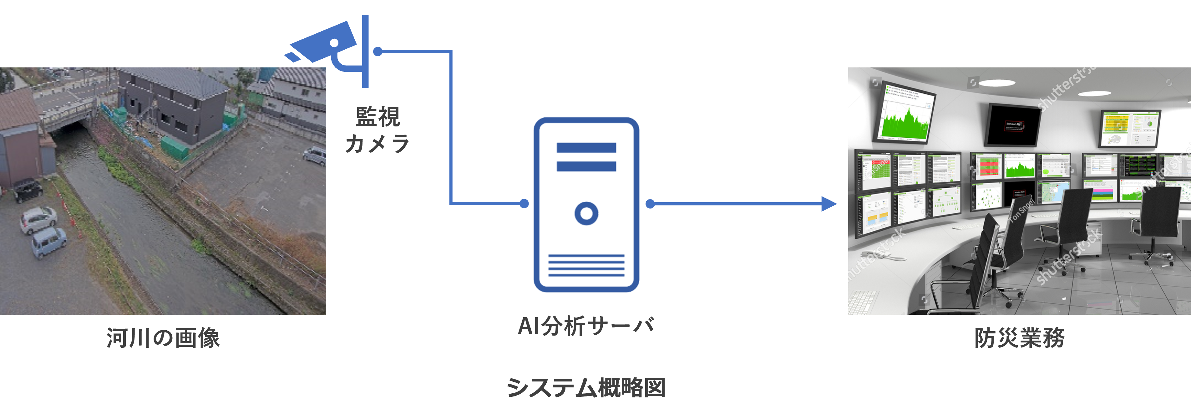
PIXEL-BY-PIXEL RECOGNITION OF THE WATER SURFACE FROM RIVER IMAGES. THE MISSING DATA IS AUGMENTED BY CG TO ACHIEVE HIGHLY ACCURATE PREDICTIONS.
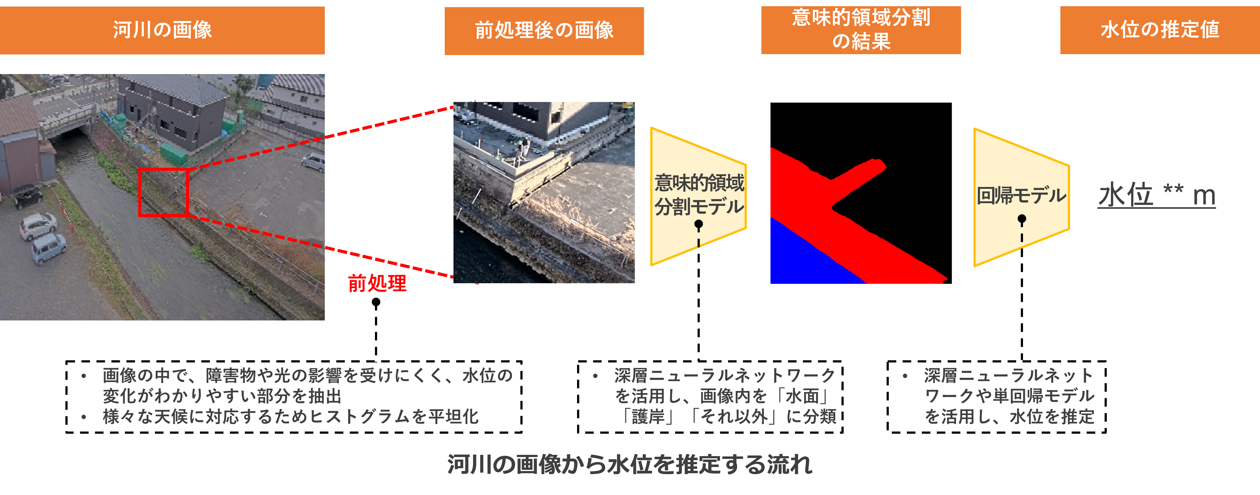
It uses a deep neural network technique called semantic segmentation, which classifies what is in the image pixel by pixel. It recognizes areas of "water surface" in an image of a river and estimates the level of the water when the water surface is at that level.
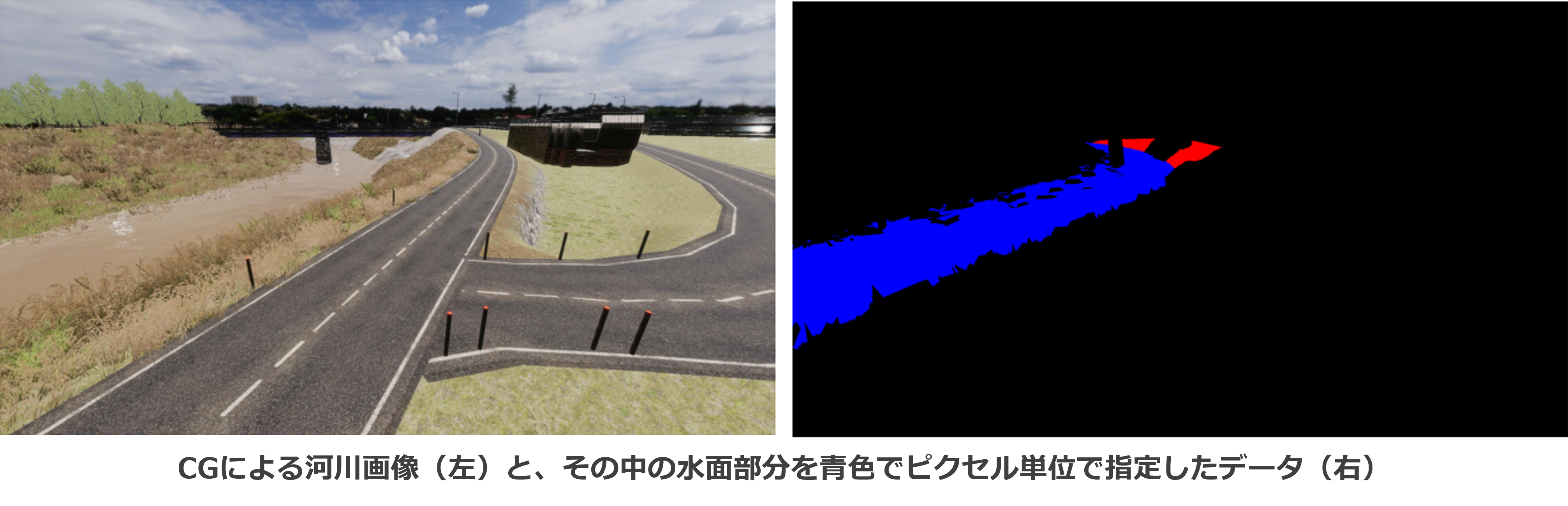
IN GENERAL, A VARIETY OF IMAGES OF WATER LEVELS ARE REQUIRED TO BUILD A HIGHLY ACCURATE AI. HOWEVER, IN THE SHORT DATA ACQUISITION PERIOD OF THIS EXPERIMENT, THERE WAS LITTLE VARIATION IN WATER LEVELS DUE TO THE LACK OF WEATHER VARIATION. TO SOLVE THIS PROBLEM, WE CREATED CG IMAGES OF VARIOUS WATER LEVELS BASED ON REAL IMAGES AND AUGMENTED THE DATA TO CREATE A HIGHLY ACCURATE AI MODEL. THIS ALSO MAKES IT EASIER TO APPLY THE MODEL TO OTHER LOCATIONS AND OTHER RIVERS (IMPROVED GENERALISABILITY).
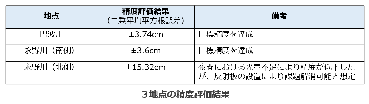
Experiments were carried out at three locations, with the best location predicting the water level with an error of ±3.6cm.
We carried out the experiment at three points and successfully estimated the water level at two points with errors of ±3.6cm and ±3.74cm respectively. At the other point, the error was only ±15.32 cm. We were able to identify the reason for the decrease in accuracy (insufficient light at night) and to suggest a method to solve the problem.
Reference
Ministry of Internal Affairs and Communications' press release: "Announcement of FY 2020 Results and FY 2021 Implementation Policy for 'Development Demonstration for Realization of Problem-Solving Local 5G, etc.
https://www.soumu.go.jp/menu_news/s-news/01ryutsu06_02000291.html